
A Different View of Rt. 279
 This photo shows a view of Rt. 279 as seen from Ridge Road looking south. Judging from the leaves on the ground, it seems to have been taken about this time of year. The main road intersected the Ridge as it does now, but the photo shows a lesser-worn path leading east to the Ridge. The flowerbed in the resulting triangle looks as though it had experienced some colder temperatures.
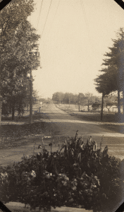
The image reveals a period of transition; Gaines was not yet completely “modernized.” In order to travel directly from the hamlet of Gaines to Albion, one would have driven down a dirt road, with transmission lines from the hydroelectric plant in Waterport on the left and telephone lines on the right. Homes on this road had access to electricity in the 1890’s, long before the rest of Gaines. Ridge Road was paved with cement in the mid-1920’s, and the curb at the base of the flower bed suggests the snapshot was taken after that development.
Dean Sprague, longtime Town Clerk for Gaines, and his wife Ethel, who lived in the house on the southeast corner of the intersection, maintained the flowerbed before the State eliminated the lesser used turn-off.
Adrienne Kirby,
Town Historian

This work is licensed under a Creative Commons Attribution-ShareAlike 4.0 International License.